Google recently highlighted Fleetminder’s use of Google’s mapping data system (API) in a case study.

“The familiar Google Maps interface makes the Fleetminder system easy to use, reducing the need for customers to train their employees. The capabilities of the Street View and Geocoding APIs helped Fleetminder create a unique Web-based dashboard and system that keeps the company on the cutting edge of its industry and makes it stand out in the highly competitive asset-tracking, fleet management market.” Mohit Khanna – CIO and Co-founder, Fleetminder
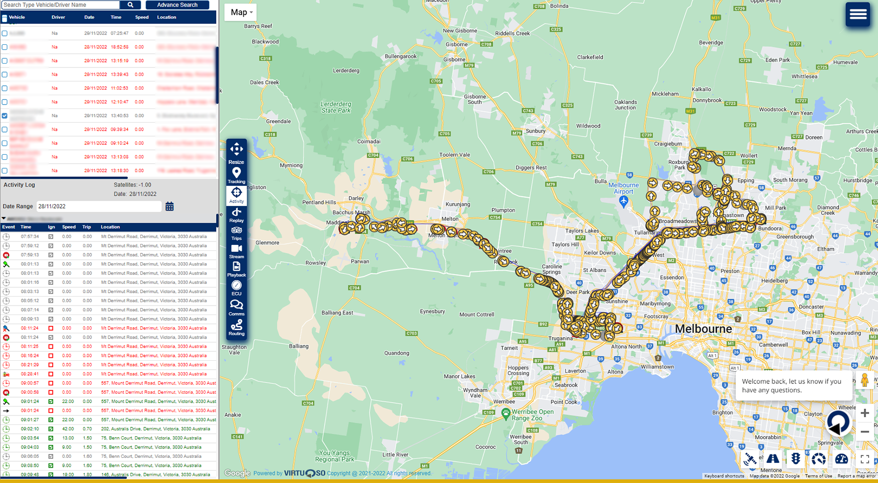
Fleetminder clients wanted a simple way to view the locations of all of the fleet vehicles at once on a map. Google Maps provided a familiar and intuitive mapping system with landmarks and other comprehensive street data that can be utilised by fleet managers and operators.
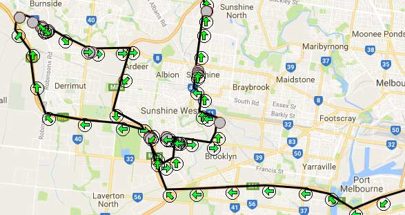
Car tracker route travelled on Google Maps
The results and mapping benefits for businesses
Google Maps APIs helped Fleetminder customers handle its fleets more efficiently and reduce costs. Since drivers spend less time on the road, employee overtime has been reduced by 25 percent. Customers now track details about driving habits, which led to a 50 percent decrease in inefficient driving. Through the use of the Geocoding API and access to Street View imagery, companies have been able to reduce the number of deliveries to incorrect addresses by 20 percent.
By being able to clearly see the location of all vehicles that might require immediate maintenance, and receiving real-time updates about accidents, dispatchers can quickly send help during emergencies. Due to constant vehicle tracking, customers recover stolen vehicles twice as quickly. Quicker recoveries mean less damage done.
With the new system, Fleetminder customers have reduced their vehicle insurance by an average of 10 percent by creating reports for insurance companies detailing driver behaviour, vehicle maintenance and fatigue management.
Fleetminder sees benefits as well, notably in attracting new clients and keeping existing ones. The familiar Google Maps interface makes the Fleetminder system easy to use, reducing the need for customers to train their employees. The capabilities of the Street View and Geocoding APIs helped Fleetminder create a unique Web-based dashboard and system that keeps the company on the cutting edge of its industry and makes it stand out in the highly competitive asset-tracking, fleet management market.
Google Maps and Fleetminder case study link
Related Posts

In today’s competitive corporate environment where businesses compete to enhance their customer base, customer satisfaction is seen as a key differentiator which decides the company’s success. Businesses who succeed in this cut-throat corporate competition are the ones that make customer satisfaction a key element of their business strategy. The demand is ever increasing and should
If you run a business that relies on a fleet of vehicles, such as delivery, transportation, or service companies, you know how challenging it can be to manage your fleet operations efficiently and effectively. You need to ensure that your vehicles are well-maintained, your drivers are safe and productive, your customers are satisfied, and your
In the realm of business vehicle management, the implementation of a tracking device is a game-changer. Fleetminder’s cutting-edge tracking devices offer a suite of benefits that can transform the way businesses operate their vehicle fleets. Driver Safety and Efficiency The safety of drivers is paramount, and tracking devices play a crucial role in ensuring it.

Car theft is a serious problem in Australia, with more than 50,000 vehicles stolen every year. If you own a car, you know how valuable and important it is to you. You use it for work, leisure, family, and more. Losing your car to theft can cause you a lot of stress, inconvenience, and financial